
Six Short Waterfall Hikes at South Cumberland State Park
One of the highlights of South Cumberland State Park, Tennessee’s largest with more than 30,800 acres scattered across several units, is its numerous waterfalls. While some are reached only by a strenuous hike, others are more easily accessible. Here are six recommended hikes of 3.4 miles or less round-trip which take in one or more waterfalls worth visiting.
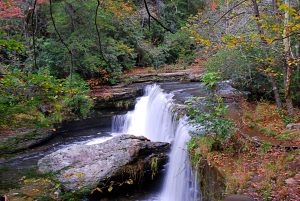
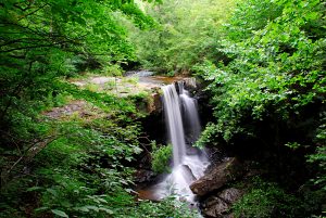
Foster Falls
One of the park’s more popular destinations, the 60-foot Foster Falls is also one of the more easily reached. While a short walk from the parking lot, much of which is on a boardwalk, takes you to an overlook of the falls, to get close you need to hike down to the bottom. A steep and rocky but short descent begins a short distance to left of the overlook and takes you to the pool at the base of the falls.
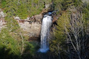 While you may return the way you hiked down, a short loop involving a slightly easier climb out, as well as another view of the falls from above, is an alternative. The Climbers Loop follows the base of the bluff for about a mile, showcasing one of the region’s more popular rock climbing locations. This trail is a bit more rugged than the relatively smooth FIery Gizzard Trail, which you may reach via either of two access trails from the Climbers Loop for the return to the parking lot. Along the way, you’ll pass another overlook with a great view from directly above Foster Falls.
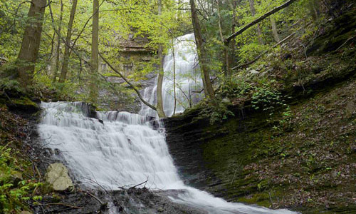
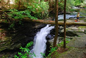
Denny Falls
A lesser-known gem is Denny Falls, located in one of the park’s newest additions, the 685-acre Denny Cove tract, which is part of the Fiery Gizzard system just south of Foster Falls. A primary feature of Denny Cove is its nearly three miles of cliffs which offer numerous rock climbing routes.
 From the trailhead, located about a mile via gravel road from U.S. 41, the main 0.45-mile access trail takes you through plateau-top forest to an intersection at the edge of the cove. Going left on the somewhat more rugged 1-mile Waterfall Trail, which traverses the slope a bit below the buffline, will bring you to the quite scenic double cascade known as Denny Falls.
Arriving back at the plateau top, a recommended short side hike to the left will take you to a double overlook of Denny Cove. While the overlook to the right is larger, the left one actually has the best view. This will total just under a three-mile hike
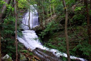
Grundy Forest
 At Grundy Forest, the northern trailhead of the Fiery Gizzard Trail, a hike of the two-mile Grundy Forest Day Loop will pass the nine-foot-high Blue Hole Falls, and the more modest Hanes Hole Falls, as well as both below and above the School Branch Falls.
Following the Fiery Gizzard Trail after it diverges from the Grundy Forest Day Loop, you will shortly pass the beautiful Black Canyon Cascades, and in 0.6 miles reach a short spur on the right which brings you to the top of the twelve-foot Sycamore Falls. Thus, a hike totaling 3.3 miles will take in five waterfalls.
Savage Falls
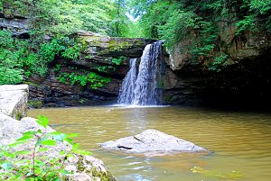 Located in the largest unit of the park, the 18,000-acre Savage Gulf State Natural Area, this 3.4-mile round-trip hike from the Savage Gulf ranger station takes you to the usually tranquil Savage Falls. At one mile in on the Savage Day Loop Trail, having crossed a suspension bridge at 0.4 miles, you’ll reach the junction with the loop section of of the trail. Turn left, and in 0.2 miles, the South Rim Trail begins on the left. Take it, cross another suspension bridge, and in about 0.5 miles Savage Falls will be on the right.
A lengthy wooden staircase leads to the pool at the base of the falls. While not particularly a spectacular falls, it can still be an enjoyable place to hang out for a bit.
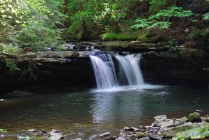
Greeter Falls
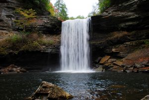
At 0.1miles from the Greeter Falls trailhead, the Blue Hole Trail forks to the right, providing the option to visit a popular swimming area upstream from the falls in 0.5 miles. Continuing on the Greeter Falls Loop Trail, you’ll come to the intersection with the loop section at 0.3 miles. Turning right, the trail descends alongside impressive overhanging bluffs, soon reaching the junction with short spur trails to the upper falls, right, and the lower falls, to the left. The trail to the lower falls uses a unique metal spiral staircase to reach the base of the falls.
 To retrace your route to the trailhead creates a hike of approximately one mile. To add another falls to the hike, go right from Greeter Falls on the Greeter Trail for 0.3 miles to the smaller Boardtree Falls, in a ravine on the right. Take the steps on the opposite side of the trail to complete the Greeter Falls Loop, rejoining the original trail at 0.3 miles from the trailhead. To do all of the options outlined here would total perhaps just under 2.5 miles.
Laurel Falls
 A modest but picturesque falls, also located in Savage Gulf State Natural Area, Laurel Falls is the primary point of interest on a short 0.3-mile loop trail which begins just to the right of the Stone Door ranger station. In 0.1 miles, after a steep descent on a wooden staircase, an overlook deck provides a great view of the falls. Continuing on the loop, at 0.2 miles the trail passes the site of the historic Laurel Mill, then returns uphill to the ranger station on a 150-year-old trail.
Find downloadable trail maps and directions to trailheads.
See trail descriptions for the Fiery Gizzard area and the Savage Gulf area.
Learn much more about South Cumberland State Park.
Article written by Bob Butters

Recent Posts

 Discover Ten Mile, Tennessee: The Hidden Lakefront Gem of Meigs CountyOctober 23, 2025
 Discover Copperhill, Tennessee: History, Train Rides, and Riverfront CharmJuly 28, 2025
 Discover Calhoun: Tennessee’s Hidden Riverfront GemJuly 10, 2025
 Murals in Southeast TNJuly 7, 2025
 North Chickamauga Creek Gorge State ParkJanuary 14, 2025